


Your journey begins in Dalaman. After arriving, you make your way to Fethiye, where one of the carefully selected hotels awaits you. Once you check in, you have the rest of the day free to relax or explore at your own pace.
 |
You can take a walk along the Fethiye Marina and Coastal Road, and for those interested in history, visiting the Fethiye Museum can be an enjoyable option. |
 |
You can shop at Paspatur Bazaar, taste local delicacies, or buy handmade products. Fethiye Castle and the Amyntas Rock Tombs are among the historical sites worth seeing. |
 |
Additionally, with boat tours departing from Fethiye Harbor, you can explore the surrounding islands and bays, and enjoy the beauty of the sea. |
 |
With an early reservation, you can stay in a sea-view room in Fethiye. If you prefer, you may choose a room with a jacuzzi or, for a small additional fee, upgrade to the King Suite. Assistance is available at any time, so you can easily get support whenever you need it. |

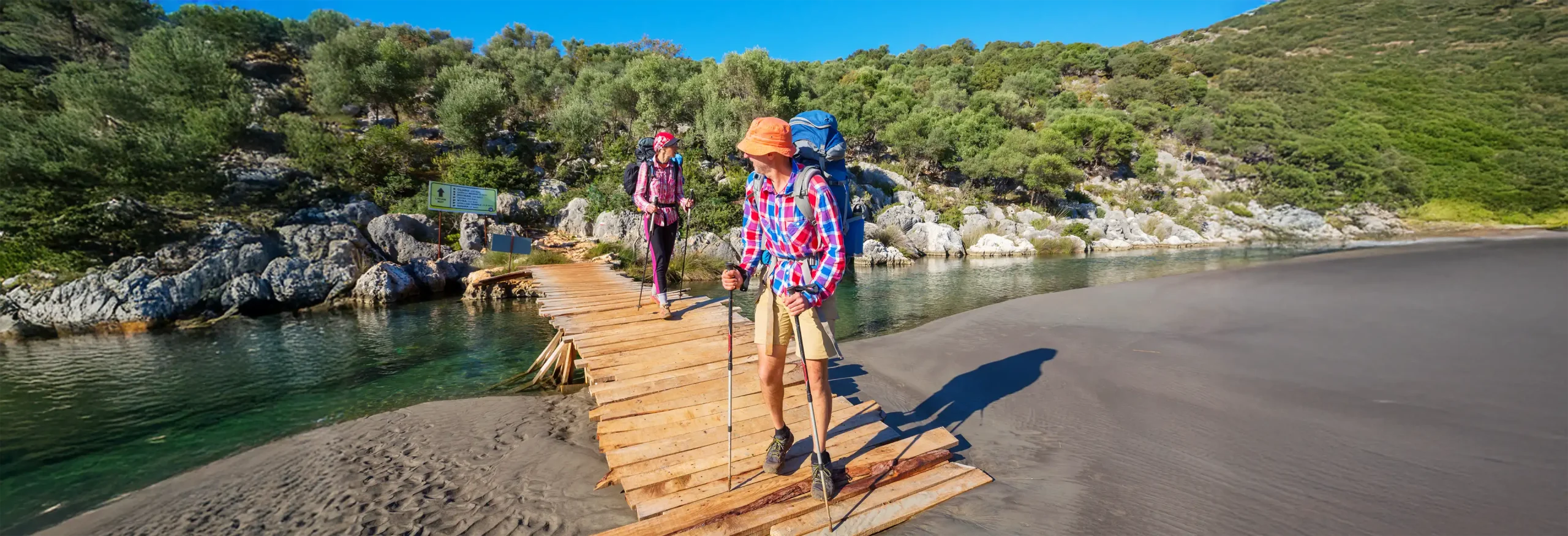
Walking Duration: 6-7 hours
Distance: 18 km / 11 miles
The route between Fethiye, Kayaköy, Ölüdeniz, and Ovacık is filled with both natural beauty and historical depth. Fethiye holds the ancient ruins of Telmessos, once an important Lycian city. On the way to Kayaköy, you pass through the abandoned Greek village with its stone houses and quiet atmosphere. Continuing along this moderately challenging trail, you reach Ölüdeniz — a place once considered sacred by the Lycians.
 |
After breakfast, you take your first step onto the Lycian Way. The first site you encounter on the trail is the ancient city of Telmessos. A short 10–15-minute walk from there leads you to the ancient theatre. |
 |
You continue from Telmessos and reach Kayaköy. Along the way, you can pass by the Kayaköy Mosque and visit Levissi — now known as the Ghost Town. In the 1920s, this area was home to a large Greek population, but the village was abandoned after the population exchange in 1923. |
 |
As you continue along the Lycian Way, just before reaching Ovacık, you’re greeted by the breathtaking view of Ölüdeniz — voted the world’s most beautiful beach in 2006 with 82% of the votes. Walking along the slopes of Babadağ, you can watch paragliders gliding gracefully from the mountain’s summit down to the turquoise waters below. |
 |
You spend the night in Ovacık, at one of the carefully selected accommodations in the area. From here, you can easily head down to one of the world’s most beautiful beaches and explore the charm of Ölüdeniz. |
 |
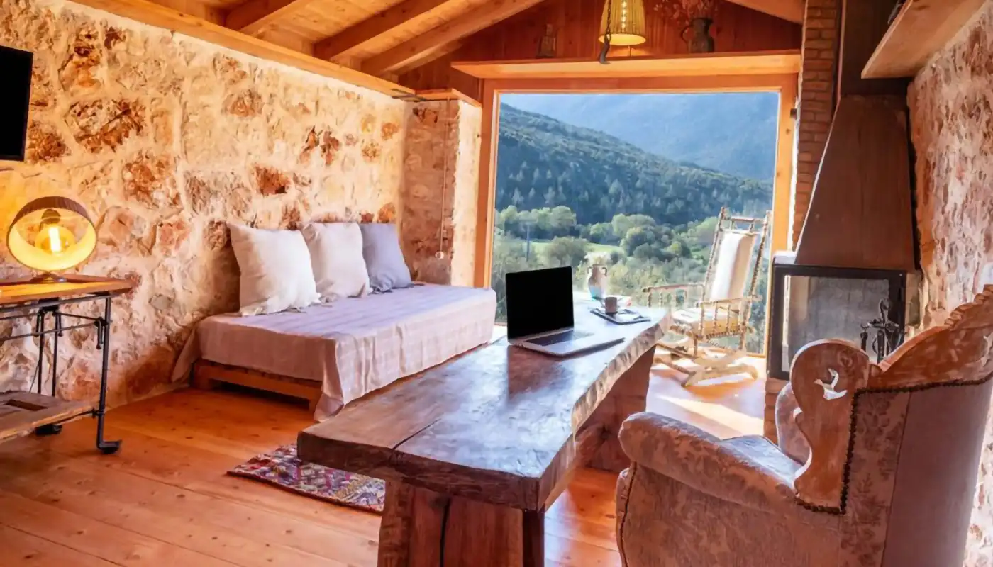
This room, reflecting the traces of the past, combines elegance with an ethnic ambiance. It’s designed to make you feel both special and relaxed, allowing you to enjoy its authentic atmosphere. |
 |
|

Walking Duration: 7-8 hours
Distance: 21 km / 13 miles
The first 5 km of this route will offer us breathtaking views. The ascent starts at 300 meters and continues up to 800 meters. The beauty of nature and the landscape during this climb is worth seeing. Afterwards, the trail continues with gentle descents and finishes at sea level.
 |
This spot is marked as the symbolic starting point of the Lycian Way. Many hikers take commemorative photos here. Don’t forget to take your picture, too. Unfortunately, a 2 km section of this path is not left natural and has been paved. After this, we rejoin the trail path. |
 |
One of the most important points of our route is Faralya, which is famous for its view. The Lycians practiced agriculture and maritime activities in this region. You can meet your water needs here and sip your coffee against the view. The remaining distance is approximately 7 km. |
 |
You end today’s hike in Kabak. Your luggage is already arranged, so you can simply enjoy the arrival. Kabak holds historical significance as an important part of the Lycian Way. Just like in Faralya, the ancient Lycians once lived here — building settlements in the valleys surrounded by mountains, where they cultivated the land and practiced maritime trade. |
 |
Kabak Beach was once a passage point used by monks and merchants along the Lycian Way. You spend the night in Kabak, at one of the carefully selected places that reflect the natural beauty and calm spirit of the area. |
 |
|

Walking Duration: 7-8 hours
Distance: 17 km / 10,5 miles
The hiking route, which starts after breakfast at Kabak Bay, passes through forested areas, olive groves over Alınca, and ancient paths to reach the ancient city of Sidyma. This route is approximately 17 kilometers long and requires a moderate to difficult level of hiking. You can find historical traces in Sidyma such as tombs and stone houses from the ancient Lycian period. As water sources on the way are limited, It’s recommended to carry enough water and use trekking poles for a more comfortable and safe hike.
 |
The acropolis of Sidyma is located on a two-part hill north of Dodurga Neighborhood. The acropolis is surrounded by walls 365 meters long and up to 3 meters high depending on the terrain. On the east, a polygonal-shaped gate and a watchtower attract attention. |
 |
The Stoa in the middle of the village, which is well preserved today and whose columns still stand, was built during the reign of Emperor Claudius (AD 41–54). Most of the local population consists of elderly women. Among the ruins of the ancient city, the neighborhood residents continue their daily lives and engage in agriculture, animal husbandry, and weaving. |
 |
They carefully grind the wheat they collect from their own fields into flour and make flatbreads over wood fires with it. By offering these lovingly prepared flatbreads to travelers walking along the Lycian Way passing beside their gardens, they both keep their traditions alive and provide a natural taste experience. |
 |
While exploring the ruins of Sidyma, you follow the stone-paved trails of the Lycian Way, gradually ascending the mountain path. Along the way, you’ll likely see many turtles crossing the road — you can feed them with cucumbers, lettuce, or leaves, and even offer them a little water during your walk. |
 |
You stay at the Mountain House, located about 15 minutes from Sidyma. Your luggage is already arranged before your arrival. Here, you can enjoy traditional flavors of Turkish cuisine and wake up to the fresh air of the forest in the morning. If you love eggs, you can collect them directly from the coop. And if you’re a barbecue enthusiast, this is the perfect place to indulge — don’t forget to ask for the stew cooked slowly over the fire. |
 |
|

Walking Duration: 7-8 hours
Distance: 15 km / 9 miles
The route starting from the ancient city of Sidyma passes through the village of Belcegiz and continues toward Gavurağılı, following an impressive trail that descends from the mountains to sea level. As you walk from Belcegiz down to Gavurağılı, you’re accompanied by panoramic sea views stretching along the coastline. This is a moderately difficult trail, and since water sources are limited, it’s important to carry enough water and have suitable hiking equipment.
 |
The acropolis of Sidyma is located on a two-part hill north of Dodurga Neighborhood. The acropolis is surrounded by walls 365 meters long and up to 3 meters high depending on the terrain. On the east, a polygonal-shaped gate and a watchtower attract attention. |
 |
From here, our direction is Gavurağılı. Since you will be coming from Bel, you can meet your water needs in Bel. While walking in this area, you will witness not only the natural beauty but also the simple and natural lifestyle of the local people. |
 |
As you progress along the road, you can see traces of the locals’ traditional lifestyles and agricultural activities, and how they live intertwined with history. You may encounter the hospitality of the people in the region. The locals continue their lives in the shadow of the Lycian Columns that have existed for centuries. As you pass between village houses under the shade of olive trees, you will witness the nature and culture of the region. |
 |
As you approach Gavurağılı, if your arrival date is in March, April, or May, you can walk through flower fields. And as you begin to descend from the summit, you will start to see the Mediterranean. |
 |
As you get closer to the coast through olive and pine trees, the color of the sea will begin to emerge. The path will take you all the way to the shore... |
 |
|
 |
They will give you memory books to preserve this adventure for a lifetime, pass your messages to future generations, and immortalize the moment, and they will say to you, “Tell the story of us.” |
Walking Duration: 4-5 hours
Distance: 16 km / 10 miles
Today, you begin your Lycian Way hike from Delikkemer. The hike is kept short so you have time in the afternoon to explore the nearby beach and historical sites. Delikkemer is a remarkable example of Roman-era water engineering, built to supply water to the ancient city of Patara. Crafted by hollowing out its center, the structure features interlocking stones and massive rock blocks. The stones were pierced and shaped by heating, and the gaps were sealed with mortar to prevent water leakage. Through this aqueduct, water was carried to ancient Patara from a distance of 22.5 kilometers.
 |
After breakfast, you start your hike from the Delikkemer section of the Lycian Way. From here, the trail descends toward the ancient city of Patara. Following the aqueduct and continuing toward the Mediterranean, you reach Patara in about four hours, passing through peaceful olive groves along the way. After 1:00 p.m., you have free time to explore the ancient city and its surroundings. |
 |
Located on the Lycian Way, the ancient city of Patara was built as one of the capitals of the Lycian League in the 2nd century BC. You can see structures from the Roman period. The ancient theatre, the Temple of Leto, and rock tombs will reveal the historical richness of the area. |
 |
You can also visit Xanthos. Whether you walk, take a minibus, or let us take you there, you can easily reach it. The first acropolis is surrounded by rising walls, while the second one is the larger and higher Roman Acropolis in the north. The name of Xanthos, the administrative center of the Lycian League, appears as ARNNA in inscriptions written in the Lycian language. Homer recounts that the Xanthians under Sarpedon’s command joined the Trojan wars. |
 |
The city was besieged in 545–546 BC by Persian Commander Harpagos. Although the Xanthians resisted heroically, when they fell into a hopeless situation, they killed their women and children and set the city on fire, leaving behind a desolate and ruined city to Harpagos. In 334 BC, Alexander the Great captured the city. The image on the side is a memory from Xanthos… |
 |
Guests who wish may go to Patara beach to swim and sunbathe. Those who want to enter the ancient city of Patara can purchase a museum pass. |
 |
You spend the night in Patara, at a hotel located close to both the beach and the ancient city. The area is surrounded by oleander and palm trees, creating a peaceful Mediterranean atmosphere. |
 |
|

Walking Duration: 6-7 hours
Distance: 17 km / 10,5 miles
In the morning, you continue your Lycian Way hike from Kalkan. Although the distance between Kalkan and Bezirgan is around 11 kilometers, the route includes some steep ascents, so it’s important to carry enough water. The trail is well-marked, allowing you to walk comfortably at your own pace. For those who prefer to skip the steep climb, the hike can begin from the Bezirgan cistern instead. The section between Bezirgan and Sarıbelen offers an easier and more relaxed walk.
 |
At the Bezirgan plateau, the grain storage barns will catch our attention. It is said that the barns built on a wooden frame date back to the year 1700. The grains are stored here to protect them from rain, floods, and moisture. Of approximately 300 barns, 125 have survived to the present day. |
 |
Sarıbelen is a highland settlement established over the Kaputaş canyon. Let’s be careful not to miss the signs on the way out of Bezirgan and during the descent to Sarıbelen. This trail is of medium difficulty. |
 |
This night has been prepared especially for you to complete your 11-day journey in the best way possible. Thanks to your early reservation, you’ll stay in a room with a terrace jacuzzi. You can unwind in the jacuzzi while watching the sunset and the night lights from your spacious terrace. As you sip your drink and take in the magnificent view around you, you’ll end your Lycian Way adventure with unforgettable moments. |
 |
In the mornings, the natural light that fills your room with the first rays of the sun creates a peaceful atmosphere, while in the evenings, your room transforms like a work of art with the colors of the sunset. In this room, where you will find traces of elegance and comfort in every corner, not only the view but also all the amenities offered will make you feel special. The peace that comes from being surrounded by nature will make every moment spent in this room unforgettable. |
 |
|

Walking Duration: 5-6 hours
Distance: 11 km / 7 miles
 |
This is a low-difficulty hiking trail that offers visually impressive views. You can find water in all settlements. This is actually the easiest route between Kalkan and Kas. You can complete the trail with slow steps on this path that runs parallel to the sea, enjoying the view. |
 |
You will spend the night in a setting we have carefully selected and believe you will enjoy. The authentic atmosphere of this place is so captivating and beautiful, it will make you feel like you've stepped into another world. The rooms, decorated with the elegant use of wood and stone, offer a comfortable stay in the heart of nature. |
 |
With the philosophy of "from nature to table," traditional meals prepared with organic vegetables and fruits grown in the garden will delight your palate. Every bite brings you the fresh flavors of nature. Additionally, the homemade jams made from their own garden’s produce will make your breakfast even more special. |
 |
|

Walking Duration: 7-8 hours
Distance: 22 km / 13,5 miles
Due to the long ascent to Phellos, this trail is considered moderate in difficulty. As you approach Phellos, trail markings may become harder to spot—please be especially mindful in this section. Among the routes between Kalkan and Kaş, this is considered the most challenging.
 |
While hiking between Gökçeören and Çukurbağ, you will pass by the ancient city of Phellos—one of the few Lycian cities with a Greek name such as Hellos and Antiphellos. The name "Phellos" means “stony land,” and its Lycian equivalent is "Vehinda." Phellos was an important city in the 4th century BC, built on a ridge that dominates the surrounding mountainous region. |
 |
Gökçeören, formerly known as "Seyret," has a history dating back to 4000–6000 BC. Numerous structures from the Lycian period have been discovered on the nearby hills, including many believed to be wine production facilities. This suggests the area was once full of grapevines, and viticulture was a major livelihood. You’ll also see centuries-old grain storage houses still standing today. |
 |
Upon reaching Çukurbağ, we’ll transfer you to your hotel in Kaş, which features a stunning sea view. Your luggage will already be delivered before your arrival. Since Kaş is famous for its colorful town center and vibrant restaurants, we leave tonight’s dinner plans up to you. |
 |
|
Today is your free day.
 |
Kaş is an ideal town that offers a perfect blend of history, culture, and seaside charm. This lively and vibrant Mediterranean gem is known for its traditional shops filled with local products. In the town center, you’ll find numerous cafés and restaurants. As you stroll through the narrow streets, you’ll enjoy browsing bohemian and ethnic clothing stores, antique shops, and handmade carpet and rug boutiques. |
 |
For sea lovers, activities like kayaking, diving, and boat tours offer the chance to enjoy the crystal-clear waters and breathtaking views. |
 |
You can also join a boat trip from Kaş to the famous “Kekova Sunken City.” |
 |
Or, with just a short boat ride from Kaş, you can reach Meis Island (Kastellorizo), which is open to visitors between 10:00 AM and 5:00 PM. Just let us know in advance if you’d like us to organize any kayaking, diving, or other activities for you. |
After breakfast, your journey from Kaş continues toward Dalaman Airport, marking the end of your Lycian Way adventure.
Warm wishes and safe travels — may your path always lead you back to new discoveries along the Lycian Way.


