
This 13-day Lycian Way itinerary covers some of the most demanding and rewarding sections of the trail along Turkey’s southwest coast. Designed for experienced hikers, the route includes sustained ascents and descents, rocky and uneven terrain, and occasional narrow or technical paths, requiring strong physical fitness and confident navigation skills.
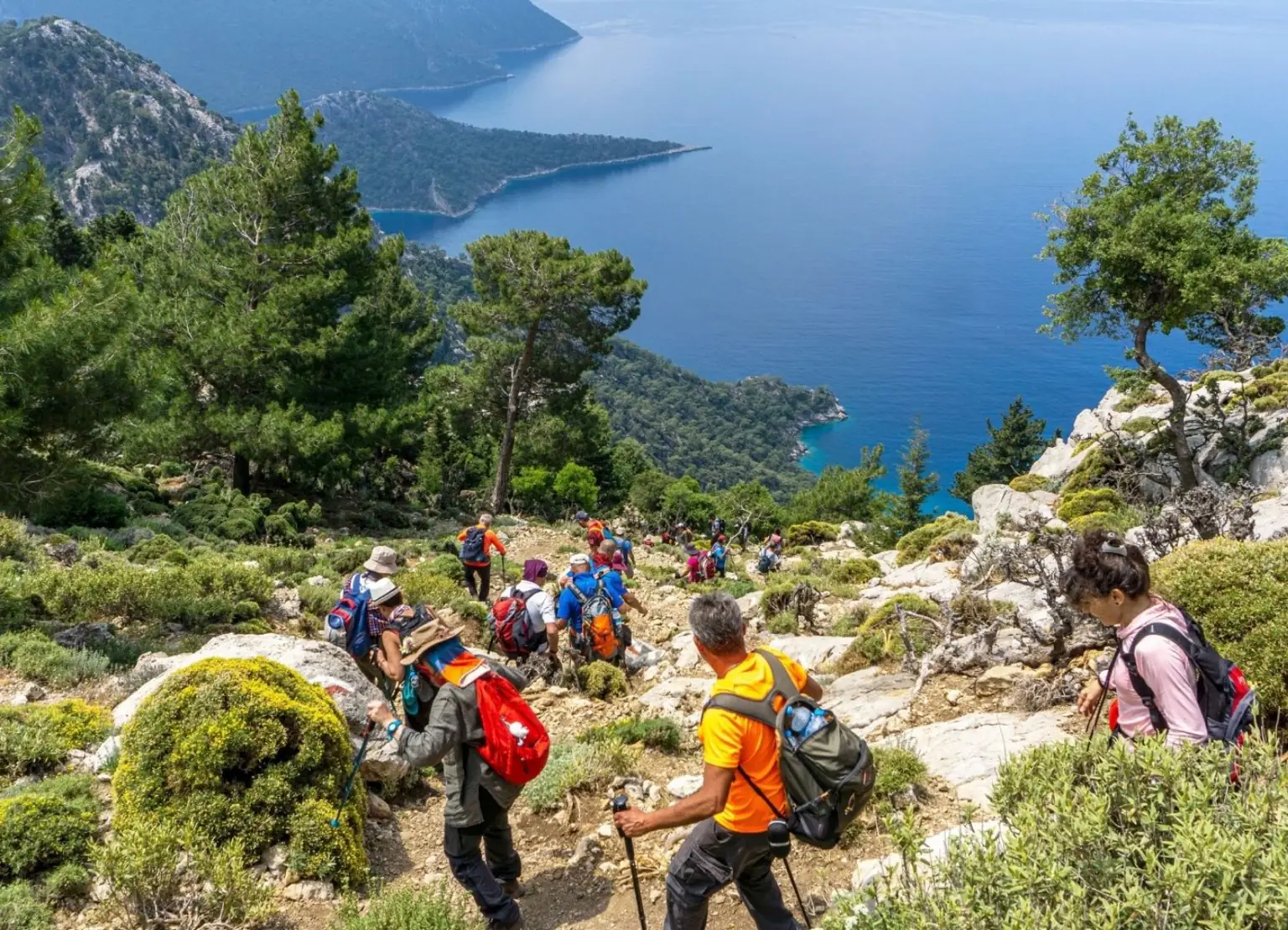
This advanced Lycian Way trek covers some of the most physically demanding and rewarding sections of the trail, combining long daily distances with significant elevation gain and sustained ascents and descents. Along the route, you will traverse a wide range of terrain, from exposed coastal paths and rocky footways to forest climbs and higher mountain sections, requiring consistent endurance and sure-footed movement.
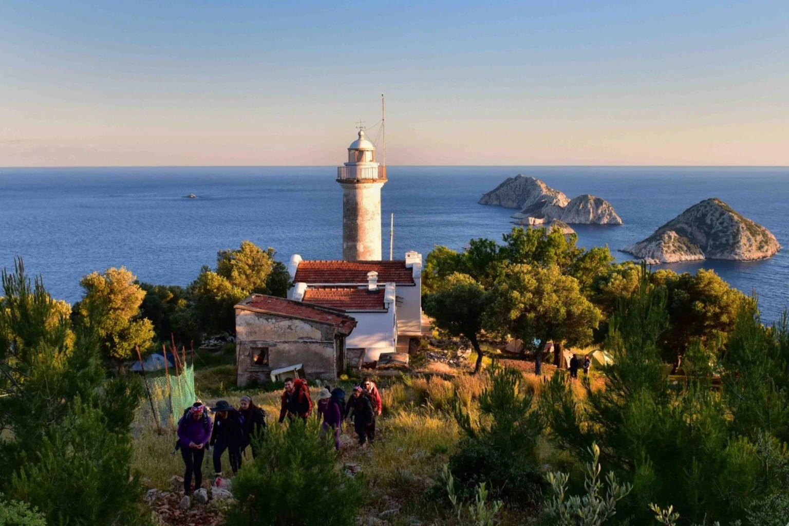
One of the standout highlights is the iconic Gelidonya Lighthouse section, widely considered one of the most scenic parts of the Lycian Way, where panoramic Mediterranean views meet rugged cliffside paths. The itinerary also passes through quieter and less-travelled areas of the trail, offering a more remote and immersive hiking experience compared to the busier western sections.
Throughout the journey, hikers encounter a mix of natural landscapes and traditional village life, with opportunities to experience local culture while maintaining a strong focus on the physical challenge of the route. Daily stages often exceed 15–20 km and include technical segments such as narrow trails, uneven surfaces, and occasional exposed sections where careful navigation and balance are essential.
This route is specifically designed for experienced long-distance hikers who are comfortable with multi-day trekking, elevation changes, and demanding terrain, and who are looking for a more challenging and authentic Lycian Way experience beyond standard walking itineraries.
This Lycian Way trek is physically demanding and designed for hikers with prior multi-day trekking experience. Expect long hiking days with sustained elevation gain and descent, requiring strong endurance and consistent pacing throughout the route.
The terrain varies continuously, including rocky coastal paths, forest tracks, and uneven mountain trails. Certain sections can be narrow, exposed, or technically challenging, particularly in more remote areas where careful footing and attention are essential.
Weather conditions can significantly influence the experience. In warmer months, heat exposure and limited water availability become key factors, especially on longer stages without reliable water sources. Early starts and proper hydration planning are important for managing these conditions effectively.
Accommodation is typically in small guesthouses and local pensions, offering a comfortable but simple level of service. Daily logistics are structured to support the physical demands of the route, with luggage transfers included so hikers can walk with a lighter daypack.
This itinerary is best suited for experienced hikers who are comfortable spending extended hours on the trail each day and who are prepared for both the physical and logistical demands of a challenging long-distance trek.
This itinerary follows a carefully selected section of the Lycian Way, combining coastal paths, forest trails, and higher mountain terrain in a structured multi-day route. The plan balances physical challenge with a realistic daily progression, including long hiking days over uneven and occasionally technical ground with regular elevation changes. The route passes through both remote sections and traditional villages, offering a mix of natural exposure and local context, while accommodation in small guesthouses and organized logistics support the demands of a sustained long-distance trek without reducing the natural difficulty of the trail.
Upon arrival at Antalya Airport, you will be met and transferred to Karaöz, a small coastal village near Menallipe Beach. The transfer takes approximately 2 hours. Karaöz is a quiet area with a simple local atmosphere and access to the sea. After arrival, you will check in to your accommodation and have the rest of the day free.
Following breakfast, a transfer leads to Karaöz, where the route continues along the Lycian Way toward Adrasan. Karaöz is a tranquil village surrounded by lush greenery, offering a calm and restorative setting.
Upon arrival in Adrasan, accommodation is arranged at a boutique hotel on the Adrasan coast, reflecting the warm colors and atmosphere of the Mediterranean.
Distance: 23.85 km |Ascent: ↑1362m | Descent: ↓1368m
Difficulty: Hard | Duration: 8 hours

The Adrasan-Çıralı Lycian Way is a challenging trail. As you’ll be walking through a forest, there won’t be opportunities to find water along the way, so bring enough for 7-8 hours walk.
The Adrasan-Çıralı Lycian Way is a tough route. Upon reaching the summit, you’ll encounter a grand valley view.
It’s an ideal spot for a break and photos. From this peak, you’ll descend toward the ancient city of Olympos and arrive in Çıralı. If desired, after dinner, you can yvisit Yanartaş (Chimaera) to see the natural flames caused by constantly burning gases, either at sunset or afterward.
Distance: 15.31 km |Ascent: ↑824m | Descent: ↓810m
Difficulty: Moderate-Hard | Duration: 7 hours

After the demanding trail of the previous day, the day is reserved for rest in Çıralı. There is an option to take a short hike to Yanartaş (Chimaera), where natural gases ignite eternal flames among the rocks. The experience is especially striking at sunset or in the evening. For those interested in history, a visit to the ancient city of Olympos is also recommended. According to legend, the name “Olympics” is linked to Olympos, a story referenced by Homer.
There is also an opportunity to walk along Çıralı Beach and enjoy the sea.
The route begins at sea level and climbs steadily, gaining significant elevation particularly along the rocky and steep paths that pass via Yanartaş (Chimera). After Yanartaş, the trail enters forested terrain and continues through coolerpine-shaded paths, though the ascent still persists. While sea views graduallyfall behind, higher sections reveal impressive panoramas of the Tahtalı Mountain surroundings.
This stage requires good fitness and can be especially demanding in hot weather; as water sources are limited, it is important to start with sufficient water. Upon reaching Beycik at the end of the day, accommodation is available in a village setting, allowing for a restful evening after the walk.
Distance: 17.87 km |Ascent: ↑1023m | Descent: ↓358m
Difficulty: Hard | Duration: 8 hours

After breakfast, you will be dropped off from your accommodation in Beycik onto the Lycian Way near Çıralı and then continue towards Tekirova. This route mostly follows the coastline, offering plenty of opportunities for scenic photos.
After passing the turquoise waters of Kıral Bay and pine forests, your next stop will be Maden Bay, where you can take a break. This bay stands out not only for its natural beauty but also for its historical and archaeological significance.
Overnight accommodation is in Tekirova, marking the completion of this section of the Lycian Way. If the day’s walk is completed early, a visit to the ancient city of Phaselis, located approximately 5 km away, is recommended.
Distance: 18.87 km |Ascent: ↑1026m | Descent: ↓1020m
Difficulty: Moderate-Hard | Duration: 8 hours

This stage begins in Tekirova and finishes in Aşağı Kuzdere, passing through the historic Phaselis Ancient City. It offers a varied, moderately challenging hike that combines coastal scenery with forest trails. The route from Tekirova to Phaselis is mostly easy and relatively flat, allowing time to explore the ancient ruins, including the theatre, agora, and harbors.
After Phaselis, the trail turns inland and gradually ascends through pine forests,with sections of rocky and dirt paths that require a moderate level of fitness. While the overall difficulty is moderate, the second half becomes more demanding due to the steady climb. Water sources are limited, so carrying sufficient water is recommended. The combination of historical sites, seaviews, and mountain landscapes makes this one of the most balanced andrewarding sections of the Lycian Way.
Distance: 19.35 km |Ascent: ↑650m | Descent: ↓605m
Difficulty: Moderate-Hard | Duration: 8 hours

This section of the Lycian Way, between Göynük Yayla and Göynük Canyon, offers a varied and engaging hike of moderate difficulty, with a few technical sections that require extra care. The route includes two descents and one ascent; the climb is relatively short but steep, demanding a reasonable level of fitness,while the overall trail maintains a balanced profile.
Waymarking is generally clear, allowing for a smooth and enjoyable walk. Along the route,you will encounter forest paths, rocky terrain, and sections following the stream, as well as occasional historical spots that invite short exploration breaks. Some sections are affected by minor land slides, leaving the ground loose and unstable; using trekking poles or a sturdy walking stick is advisable for better balance. Although the route ends near a settlement, it is wise to carry a light meal in case of delays and to plan ahead to avoid finishing after dark.
Distance: 13.49 km |Ascent: ↑672m | Descent: ↓1453m
Difficulty: Hard | Duration: 7 hours

The walk from Göynük Canyon to Elmayanı Pınarı is one of the more demanding sections of the Lycian Way, featuring a sustained ascent from near sea level into the forested highlands. The route begins with a steady climb out of the canyon, quickly gaining elevation on rocky and uneven terrain before continuing through pine forests and shaded mountain paths. This stage is considered moderate to challenging, particularly in warm conditions, as the ascent can be long and exposed in places.
Waymarking is generally reliable, but attention is required at junctions. Water sources are limited, making Elmayanı Pınarı an important refill point, though flow canvary seasonally; carrying sufficient water from the start is essential. The combination of elevation gain, natural terrain, and quieter surroundings makes this a physically rewarding but less crowded stretch, best suited to hikers with good fitness and proper preparation.
Distance: 11.89 km |Ascent: ↑1554m | Descent: ↓155m
Difficulty: Hard (T4–T5) | Duration: 8 hours

This section from Elmayanı Pınarı to Çitdibi offers a cooler and more balanced hiking experience along higher elevations. The route generally follows gentle ascents and descents, with fewer steep climbs compared to previous stages. Along the way,the trail passes through pine and cedar forests, with a mix of rocky and dirtpaths, while open clearings and upland views add a spacious feel to the walk.
Rated as moderate in difficulty, the route is not technically demanding but still requires a reasonable level of fitness due to its distance and duration. Waymarking is generally clear, though extra attention is needed in forested sections.
Distance: 16.6 km |Ascent: ↑564m | Descent: ↓1248m
Difficulty: Hard | Duration: 8 hours

This stage from Çitdibi to Geyikbayırı offers an enjoyable, moderately challenging hike through mountainous and forested terrain. The route follows a generally balanced profile with a mix of ascents and descents, including some longer, gradual climbs.
Along the way, the trail alternates between pine forests, rocky paths, and dirt tracks, while occasional open sections reveal views of surrounding mountainranges and upland landscapes.
Accommodation will be arranged either in this area or in Antalya, depending on availability.
Distance: 17.19 km |Ascent: ↑1072m | Descent: ↓1434m
Difficulty: Hard | Duration: 6–8 hours

Before the airport transfer on the following day, the final day of the program is spent in Antalya. After breakfast, travel continues from Geyikbayırı to the hotel in Antalya, a scenic coastal journey of approximately 45 mins.
One ofthe city’s most famous structures, Hadrian’s Gate, is a symbol of Kaleiçi, Antalya’s old town, where you can explore narrow streets, historic buildings, and shop. Düden Waterfall, another natural beauty, is very close to the city center.
The Antalya Museum offers a rich collection for those eager to explore the region’s history. Additionally, Termessos Ancient City, perched atop a mountain, may captivate you with its impressive views and historical ruins. Since it’s freetime, we’ll leave dinner up to you.
For those wanting to extend their day in Antalya, you can visit Manavgat or Düden Waterfalls.
After breakfast, transfer to Antalya Airport (9 km) is provided.
We place strong emphasis on creating a walking experience tailored entirely to you.
Your itinerary can be customized based on your daily walking pace, preferred duration, and desired difficulty level. Whether you want shorter days, more challenging routes, rest days, or specific locations included, we build your itinerary accordingly.
Your dietary preferences and any allergies are carefully considered as well.
In addition, we can incorporate the places you are most curious about along the Lycian Way, creating a journey that reflects your personal interests.
The itineraries presented on our website are standard packages, designed based on the most popular choices among our guests.
To get started, simply share your preferences and expectations with us, and we will create a well-balanced, personalized itinerary designed just for you. NO EXTRA COST!